
Indianapolis I-65/I-70 Southeast Gateway
Planning Study Report
Final Draft
Home : : Our Work : : Southeast Gateway : : Planning Study Report
Table of Contents
The Problem
The Planning Study Area: Then and Now
A System-Wide Vision
Precedent Studies
Learning from Transformational Projects in Indianapolis
Learning from Similar Projects in Other Cities and States
Planning Study Results and Considerations
Structure
Timeline
Defining the Community’s Vision
Q4 2024 to Q1 2025
Q2 to Q3 2025
Q4 2025
Benefit-Cost Analysis
Cap Concepts
Concept 3 (Preferred)
Concept 2
Concept 1
Analysis of Key Objectives for Each Concept
Investment Returns
Funding and Governance for Long-Term Success
Funding
Value Capture
An Innovation Corridor
Why an innovation corridor?
What kind of innovation corridor?
Governance
Launching the Next Era of Growth
Innovation Corridor Development: Roadmap
Ongoing Engagement
Initial Assessment
Innovation Corridor Planning
Implement the Master Plan
Download the report
and the supporting documents
Acknowledgements
Rethink Coalition wants to thank the following organizations, groups, and people who participated in meetings, discussions, and work to make this Planning Study a success:
Rethink Coalition Board of Directors
Brenda Freije, RC President and CEO
Planning Study Project Manager
Charlie Richardson, Faegre Drinker (ret.)
RC Co-Chair (At-Large)
Planning Study Team
Russell Menyhart, Taft,
RC Co-Chair (At-Large)
Planning Study Team
Taylor Hughes, Indy Chamber
RC Board (Indy Chamber Rep.)
Planning Study Team
A’Lelia Bundles, Civic Leader
RC Board (Indianapolis Foundation Rep.)
Bruce Buchanan, Buchanan Group
RC Treasurer (Indiana Landmarks Rep.)
Susan Brock Williams, Eli Lilly & Co
RC Director (Indy Chamber Rep.)
Adairius Gardner, IU Health
RC Director (At-Large)
Lourenzo Giple, SMEUSA and Design Consultant
RC Director (Indianapolis Foundation Rep.)
Chris Jensen, City of Noblesville Mayor
RC Director (At-Large)
Marjorie Kienle, Civic Leader
RC Director (At-Large)
Sarah Hempstead, Schmidt Associates
RC Director (Indy Chamber Rep.)
Suzanne Stanis, Indiana Landmarks
RC Director (Indiana Landmarks Rep.)
Rethink Coalition Supported Organizations
Indy Chamber
Indianapolis Foundation
Indiana Landmarks
Indy Chamber
Finance, Economic Development, and Governance
Matt Mindrum
Taylor Hughes
Storrow Kinsella Associates
Technical Design, Community Engagement
Meg Storrow
John Kinsella
City of Indianapolis
Joe Hogsett, Mayor
Dan Parker, Chief of Staff, Mayor’s Office
Nathan Sheets, Department of Public Works
Mark Zwoyer, DPW Consultant
Indiana Department of Transportation (INDOT)
Lyndsay Quist, Commissioner
Sandra Flum
Jonathan Wallace
INDOT ProPEL Indy Consultants
Tim Miller, HNTB
Kia Gillette, HNTB
American Structurepoint, Inc.
Infrastructure Engineering and Planning
Rich Zielinski
Eric Farny
Joe Westfall
Sarah Everhart
Mason Dreiling
Juan Ortiz
Patrick O’Connor
Troy Jessop
Kevin Gorak
Tim Thomas
Brad Whitehead
Jacob Cook
Rundell Ernstberger Associates, Inc.
Urban Design, Landscape Architecture, Planning
Kevin Osburn
Kevin Sweetland
Travis Johnson
Jiaxi Wu
Xizi Yu
Enzo Lundy
Remy Locke
DLZ
Engineering and Planning
Jeff Swenson
Haseeb Ghumman
Charles Fawcett
Xin Tian
Justways Research
Community Research and Engagement
Abbey Chambers
The History Concierge
Community Research and Engagement
Jordan Ryan
Scotty & Co.
Website, Communications, and Engagement
Scotty Z. Wilson
Rethink Coalition Advisors
Jennifer Baskerville-Burrows
Episcopal Dioceses of Indianapolis
Paula Brooks
Hoosier Environmental Council
Steve Campbell
Indianapolis Colts
Garry Chilluffo
Chilluffo Media
Marsh Davis
Indiana Landmarks (Retired)
Bruce Donaldson
Barnes & Thornburg (Retired)
Mark Fisher
Indiana REALTORS
Justin Garrett Moore
Mellon Foundation
Austin Gibble
Santec
Ryan Hamlett
Glick Properties
Kären Haley
Indianapolis Cultural Trail
Marjorie Hennessy
Health by Design
Brandon Herget
Heritage Group
Mackenzie Higgins
Elanco
Charlie Hyde
Benjamin Harrison Presidential Site
Kim Irwin
Public Health Professional
Joe Jarzen
Schmidt Associates
Michael Huber
Indiana University
Lee Little
Episcopal Church
Marc McAleavey
Health by Design
Rickey McCray
The Way Church
Steven Meyer
Intend Indiana
Allyson Mitchell
Apkudo
Polina Osherov
Pattern
Brian Payne
CICF (Retired)
Jason Shelley
American Institute of Architects
Riley Spelman
Indiana University Health
Eunice Trotter
Indiana Landmarks, Black Heritage Preservation
Tyler Warman
Indiana County Commissioners
Arup US, Inc.
Technical Design, Economic Development
Abigail Rolon
Kristi Tu
Cristina Mireilla
James Cretella
Lauren Romeo
Santiago Icaza
Akhil Pulianda
Barnes & Thornburg
Legal
Bruce Donaldson (Ret.)
Brad Bingham
Consultant
Finance, Economic Development, and Governance
David Gogol
Faegre Drinker
Legal
Matt Olsen
Crowe LLP
Legal
Angie Steeno
Becca Zakowski
Switchboard
Workshop and Meetings Location
Allegro Accounting Services LLC
Admin and Accounting
Lauren Walawender
Consultant
Communications, Social Media, and Engagement
Andrea Watts
Consultant
Community Engagement
Bruce Colville
Fountain Fletcher District Association
Community Research and Engagement
Laura Giffel
The 64 Community and Civic Leaders and Organizations
listed here and attached supported this Planning Study with letters and hours of time dedicated to reviewing concepts, providing feedback, and sharing ideas to shape the vision.
A’Lelia Bundles
Bates-Hendricks Neighborhood Association
Sharon Battista (Business Owner and Commercial Landlord, Bluebeard Restaurant)
Tom Battista (Business Owner, Amelia’s Bakery)
Bean Creek Neighborhood Association
Benjamin Harrison Presidential Site
Big Car Collaborative
Central Indiana Community Foundation (CICF)
Central Indiana Corporate Partnership (CICP)
City of Indianapolis, Department of Metropolitan Development
City of Indianapolis, Office of Sustainability
Cole-Noble Neighborhood Association
Connected Communities Initiative (CICF)
Cummins Inc.
Develop Indy
Downtown Indy Inc.
Eli Lilly and Company (received after grant was submitted)
Fletcher Place Neighborhood Organization
Fountain Fletcher District Association
Fountain Square Alliance
Fountain Square Neighborhood Association
Friends of the White River
Garfield Park Neighborhood Association
Health By Design
Historic Urban Neighborhoods of Indianapolis (HUNI)
Holy Cross Neighborhood Association
Hotel Tango Distillery
Indiana Landmarks
Indiana Pacers
Indiana State Representative Blake Johnson
Indiana State Representative Justin Moed
Indianapolis City-County Councilor, President Vop Osili
Indianapolis City-County Councilor, Vice President Zach Adamson
Indianapolis City-County Councilor Kristin Jones
Indianapolis Colts
Indianapolis Cultural Trail
Indianapolis Metropolitan Planning Organization
Indy Chamber
IndyGo
IU Environmental Resilience Institute
IUPUI Office of the Chancellor
KHEPRW Institute
Lockerbie Square Historic Neighborhood
Mass Avenue Cultural Arts District
Meridian-Kessler Neighborhood Association
Meridian Street United Methodist Church
MIBOR Realtor Association
North Square Neighborhood Association
Old Southside Land Use Committee
Prospect Falls Neighborhood Association
Reconnecting to Our Waterways
Roberts Park United Methodist Church
School 9, LLC
Second Presbyterian Church
Southeast Community Services (SECS)
Southeast Neighborhood Development (SEND)
St. Luke's United Methodist Church
Stadium Village Business Association
The Parks Alliance of Indianapolis
University Heights Neighborhood Association
University of Indianapolis
Villaggio at Page Pointe Homeowners Association
Voices
Young & Laramore
Introduction
Indianapolis has an incredible opportunity to reconnect its neighborhoods in a way that dramatically improves prospects for long-term economic, social, and environmental viability. Rethink Coalition, a 501(c)(3) charitable organization, in partnership with the City of Indianapolis, and The Greater Indianapolis Chamber of Commerce and Foundation (Indy Chamber), and in cooperation with the Indiana Department of Transportation (INDOT) have completed a Planning Study of the redesign of the I-65/I-70 Southeast Gateway of the Interstate Inner Loop in downtown Indianapolis to reconnect neighborhoods divided by the interstate through a comprehensive redevelopment plan (the SE Gateway Plan or Plan).
The Plan involves constructing an interstate cap to create green spaces, enhance transit, biking, and walking options, enable land for redevelopment, and improve local street grid. The Plan is part of the Rethink Coalition’s efforts to address the disconnection caused by the original Inner Loop constructed in the 1970s, which led to economic decline and fragmented communities. The Plan demonstrates how recessing and capping the Inner Loop can accelerate urban development, improve quality of life, heal the injustices caused by the original interstate construction, and move traffic and transport efficiently and effectively.
Key Objectives for the Study Area
Improve Quality of Life
1.
Build a lot more housing, including affordable and mixed-use options, add more jobs, parks, and greenspaces, and increase access to amenities, services, and third places for people to gather, socialize, and build community.
Increase Connectivity
2.
Improve walkability, expand the biking network, increase transit usage through transit-oriented development, and improve driving infrastructure.
Make the Streets Safer
3.
Improve dangerous intersections, calm traffic on major thoroughfares, and make pedestrian and cycling networks safer.
Reduce noise and air pollution, reduce the interstates’ visual impacts; repurpose interstate land for more productive uses.
Reduce the Environmental Impacts of the Interstates
4.
Create Opportunities for Economic Development
5.
Maximize the quality and value of land and increase the local tax base.
This Report presents the results of the Planning Study, integrating the work of the Study Team’s consultants with the prior studies and resources that informed and shaped their analysis. It starts with setting the foundation for the Planning Study, exploring the problem the original Inner Loop created in the Study Area, the impacts still felt today, a System-Wide Vision for the Inner Loop, the studies this Planning Study builds on, and learnings from infrastructure projects in Indianapolis and capping projects from around the country important to analyzing the interstate capping options for the Study Area and around the Inner Loop. The Report then moves into a discussion of the three capping options and considerations for the Study Area, analyzing each option in relation to the Key Objectives and identifying a preferred option. The Report concludes with clear next steps and a funding and implementation strategy for the preferred design—centered on launching an innovation corridor in downtown Indianapolis as a catalytic engine for economic growth and long-term value creation to fully realize the System-Wide Vision.
The reports and resources informing this Planning Study are listed below and attached.
Southeast Gateway Planning Study Letters of Support
Southeast Gateway Planning Study Historical Research Narrative and Findings
Indianapolis Downtown Interstate 65/70 System Strategic Advisory (Arup, 2018)
Indianapolis Inner Loop Total Value Report and Executive Summary (Arup and Indy Chamber, 2021)
Rethink Coalition ProPEL Indy 2025 10-5 Comment Letter with Attachments
Reasons to Love the Indianapolis Cultural Trail - A Legacy of Gene and Marilyn Glick
(Indiana University Public Policy Institute, 2015)
Assessment of the Impact of the Indianapolis Cultural Trail: A Legacy of Gene and Marilyn Glick (Indiana University Public Policy Institute, 2015)
Indianapolis Transformational Project Overview (Ginovus, 2023)
Southeast Gateway Planning Study Survey of US Recessed/Capped Interstate Projects
Southeast Gateway Planning Study Communities Finance, Economic Development, and
Governance Research and Resources
Southeast Gateway Planning Study Community Engagement Report
Southeast Gateway Planning Study Conditions Assessment
Appendix A. Location Maps Final Report
Appendix B. Traffic Analysis Memo
Appendix C. Environmental Constraints Report
Appendix D. Concept Drawings
Appendix E. Schematic Drawings
Appendix F. Opinion of Probable Cost
Appendix G. Final Concept Alternatives Definition Memorandum
Appendix H. Risk Register
Southeast Gateway Planning Study Community Engagement Workshop #3 Presentation
Slides
Southeast Gateway Planning Study Benefit-Cost Analysis
Southeast Gateway Planning Study Funding and Financing Mechanisms: Compilation of
Information Report
Southeast Gateway Planning Study Value Capture Districts in Indiana Memo
Articles:
University-Anchored Innovation Districts
Mission-Oriented Innovation Districts
The Rise of Innovation Districts (Article and Report)
South Bend RDC Approves $31M Bond to Advance Notre Dame Tech and Talent District
Southeast Gateway Planning Study Abandoned Railroad Bridge Memo
Setting the Foundation
The Problem
The Interstate Highway System dramatically reshaped America's cities. In Indianapolis, when the interstates were constructed, little thought was given to the overall future development of the downtown. The overriding consideration was traffic flow and capacity. Nonetheless, in Indianapolis and in other cities, the interstates profoundly shaped city development. With massive, man-made hills on three sides of the central area and blocks of adjacent areas rendered unusable, the footprint of downtown Indianapolis was fixed to accommodate interstate travel. In virtually every other large city, the interstate comes through on bridges or in tunnels, approaches that were bad but had less impact than the manmade hills of Indianapolis. With today's understanding of cities, no one would repeat the decisions that were made in Indianapolis about the placement and design of the interstates.
Through several years of careful study and work, we know that the raised segments of the Inner Loop can be replaced with recessed interstates in a compressed footprint that will manage increased volume on the interstates, increase safety, and dramatically improve intra- city traffic and connectivity, all while achieving important quality of life and economic development goals. The recessed alternative meets all the needs and requirements of an interstate highway AND addresses the realities of 21st -century downtowns.
1950s and 60s Thinking
In the 1950's and 60's, downtowns were seen as compact areas of offices and commercial activity. Zoning and other tools were used to separate a city’s functions. Today, cities across the world are rethinking urban development, recognizing that heterogeneous development with housing, offices, and commercial activity inter-mixed are key.
If downtown Indianapolis were to consist only of office towers and government buildings, the existing mounds encircling the downtown might be acceptable. But that is not the present or future of Indianapolis. After a multi-decade period of decline in downtown Indianapolis, the City recognized that downtown should and could be more than a 9-5 place to work. New housing, hotels, higher education, health care, entertainment, and sports are the drivers of downtown Indianapolis’ rebirth, not new office towers or government buildings. If Indianapolis is to thrive in the future, it cannot be artificially constrained by highway mountains. We must return the hundreds of acres devoted to the Interstates to productive use and allow downtown to grow outward from the urban core. No one knows what downtown Indianapolis will look like in 2050, but we do know it will not look like downtown in 1950.
As we rebuild the interstates in downtown Indianapolis, traffic flow must be a consideration, but not the only consideration. Instead of making downtown Indianapolis bend to the needs of interstate travel, we must rebuild in a manner that accommodates interstate travel and the future of Indianapolis.
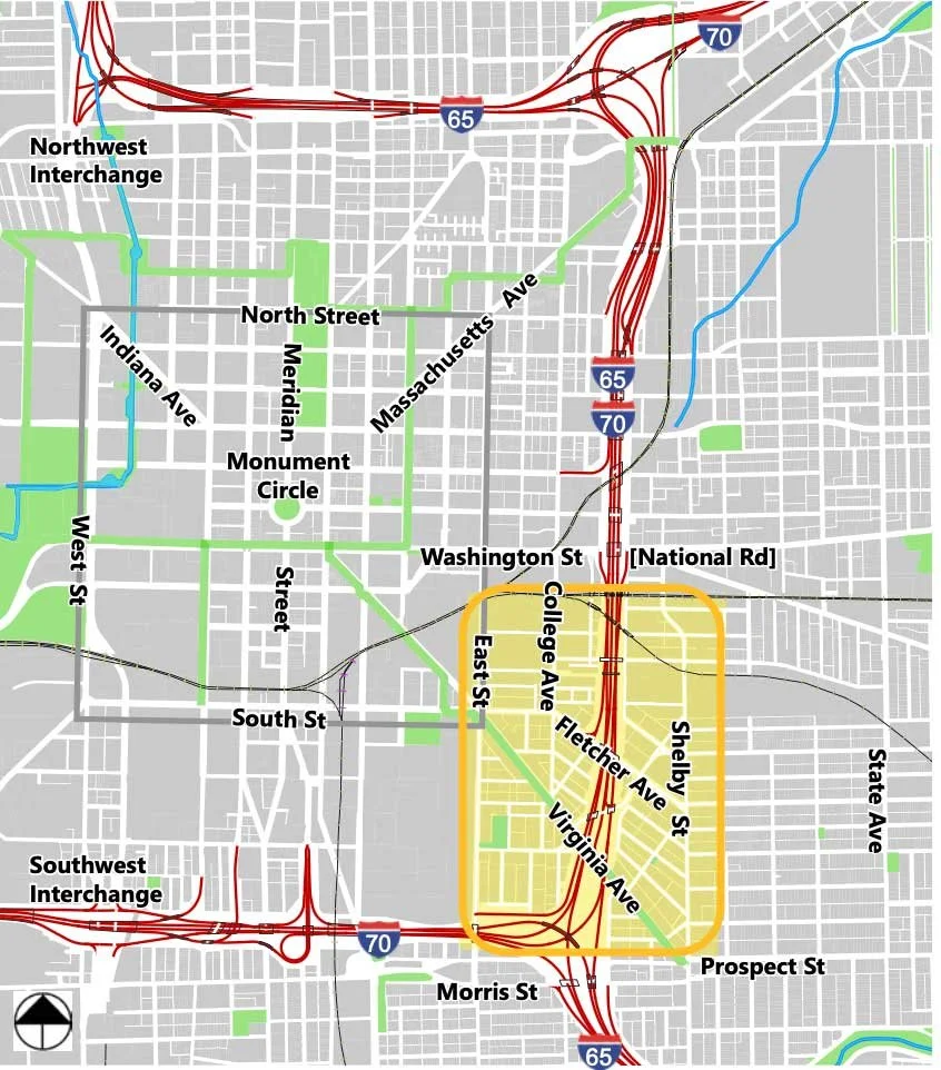
The Planning Study Area:
Then and Now
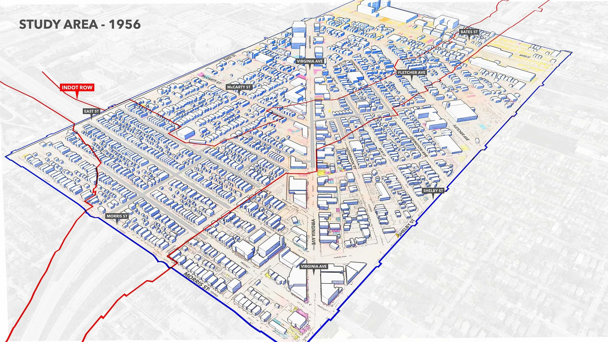
The problems created by the 1960s interstate design are significant and long-lasting in the Study Area. As the Research Narrative to the Southeast Gateway Study Project Research Findings for the I-65/I-70 Inner Loop explains, the 1910s to the 1950s, prior to the construction of the interstates, was a significant “Golden Era” period of development for the Fountain Square and Fletcher Place neighborhoods at the center of the Study Area. (Attachment 2) This thriving, working-class community continued to develop, with the population of the general area peaking at over 27,000 residents by 1950. The neighborhood was densely populated with both wood-sided and brick dwellings, many individual homes, some duplexes and apartments, churches, and a community center. The area also contained many movie theaters, shops, and businesses, making it a thriving hub of commerce, shopping, and entertainment.
By the middle of the twentieth century, the district began to face planning and development challenges similar to those of other cities’ downtown neighborhoods. Automobile culture continued to grow in popularity. As new suburban neighborhoods with new, mid-century modern shopping centers were built outside of the city and new highway systems were built to reach these new suburbs with their new, mid-century modern shopping centers, many residents were enticed to relocate away from the neighborhood’s commercial corridor and from downtown.
The downturn continued when the 1956 Federal-Aid Highway Act reached Indianapolis. In the 1960s, the interstate highway routes of I-65, I-70, the I-65/70 Inner Loop, as well as the I- 465 outside ring, were designed, properties were purchased, and families, businesses, churches, and schools were displaced en masse. The I-65/I-70 Inner Loop south split interchange cut the Fletcher Place neighborhood off from Fountain Square and Bates- Hendricks, while cutting Fountain Square off entirely from downtown’s Central Business District. I-65/I-70 officially opened in 1976, forever altering the community. Thousands of families lost their homes, significantly decreasing the neighborhood’s population by some accounts up to 30%.
Study Area – 1956
Study Area – 2025
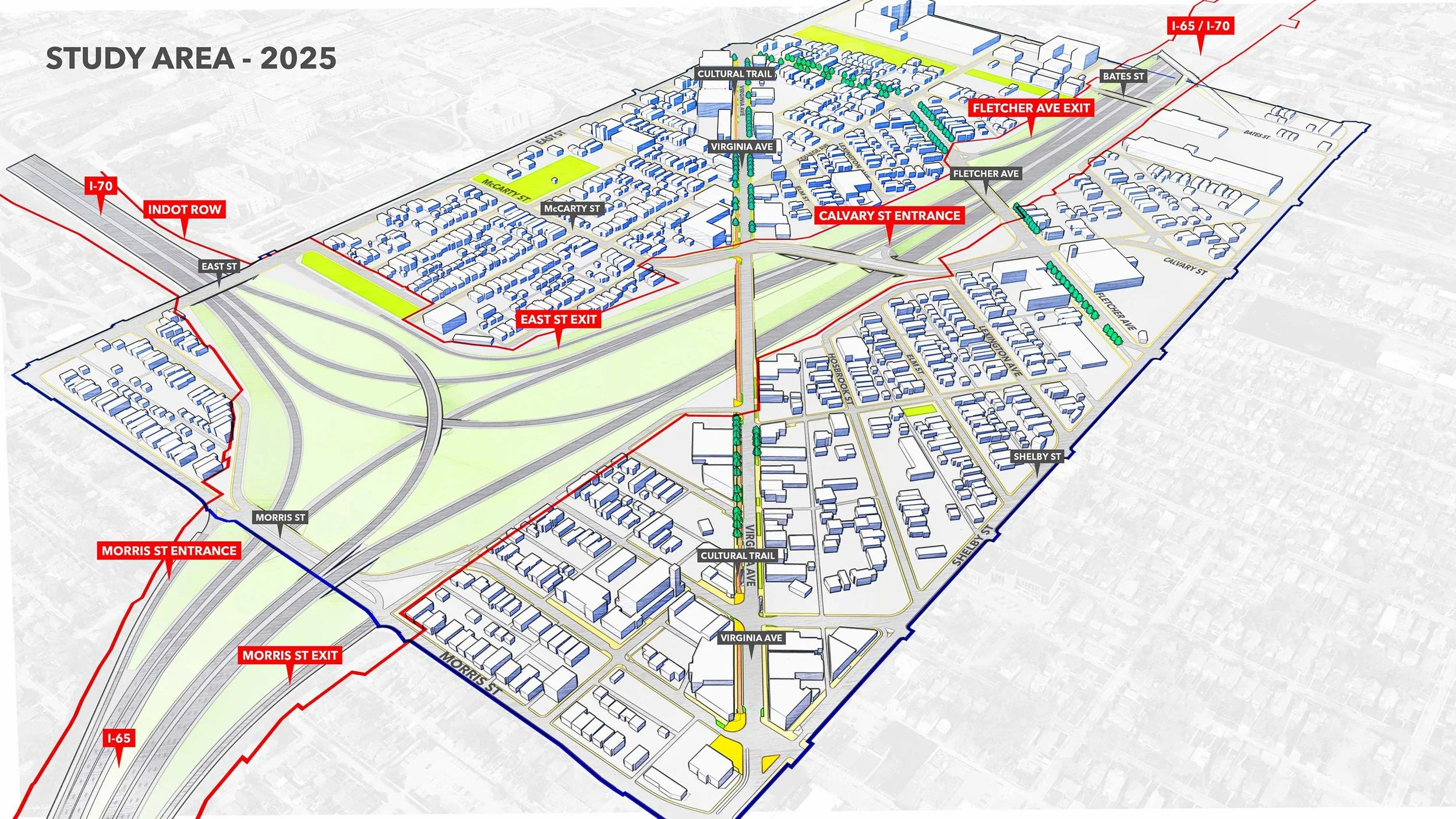
These images show the vast swaths of houses and businesses removed to make way for the interstates.
The problems with interstate construction in dense urban areas and urban renewal projects are not unique to Indianapolis. But we risk falling behind other cities and states that are taking proactive action with their urban interstates.
As explained in more detail below, the Study Team examined what cities and states across the country have done to eliminate, modify, and otherwise modernize their urban interstates, undo past damage, and deliver enduring public benefit. We also participated in national conversations about that reform to capture best practices and realistic solutions. We’ve taken a hard look at feasibility and cost as we estimate economic returns from infrastructure investment.
As other states rethink their urban interstate infrastructure and gain significant advantages, our 1960s-style urban interstate infrastructure undermines Indiana’s competitiveness. We must do better with the gigantic backward “C” that is the Inner Loop and with the West Street Corridor (the fourth leg of the Inner Loop that was never built).
A System-Wide Vision
Rethink Coalition’s vision is a reconstructed I-65/I-70 Inner Loop that reshapes life, health, and economic growth in Central Indiana for the next 50+ years. We can accomplish this with a recessed, open-air interstate system featuring a compressed footprint and strategic capping. This will make room for additional economic development and value capture to help with up- front building costs, while improving connectivity and livability.
This image shows a recessed Inner Loop system with a compressed footprint freeing up State-owned interstate right-of-way (highlighted in blue) for redevelopment.
A recessed, compressed interstate system with strategic capping will:
Manage increased volume on the interstates,
Increase safety,
Dramatically improve intra-city traffic and connectivity,
Free up developable land,
Catalyze the development of underutilized land near the interstates,
Unleash billions of dollars in economic development potential,
Increase tax revenue,
Create a better environment for visitors, residents, students, and workers,
Reconnect neighborhoods, improving people’s access to jobs and services, and
Pay for itself.
The foundation for this vision is built on two feasibility and benefit studies and the results of INDOT’s ProPEL Indy, a study that engaged residents, businesses, and community organizations in Central Indiana to envision the future of I-65 and I-70 inside the I-465 loop in Indianapolis, including downtown Indianapolis.
Precedent Studies
The SE Gateway Planning Study builds on two prior studies prepared by Arup US, Inc., a global engineering firm that served as part of the Study Team. Those prior studies, made possible with significant funding from the Lilly Endowment, evaluate how interstate construction fifty years ago impacted disadvantaged communities and continues to burden vulnerable populations today. They also examined the technical feasibility and exponential benefits of rethinking how the Inner Loop will be reconstructed now that it is nearing the end of its lifespan:
The Indianapolis Downtown Interstate 65/70 System Strategic Advisory (2018) evaluates economic development opportunities and financing/delivery alternatives in rebuilding the Inner Loop. (Attachment 3)
The Inner Loop Total Value Report (2021) provides a high-level evaluation of two alternatives for rebuilding the Inner Loop: (1) rebuilding with the current configuration and (2) rebuilding with a recessed urban freeway and multimodal boulevards that replace the limited point access of the current connector-distributor system, restore local street grid integrity, and create infill opportunities for balanced development. (Attachment 4)
Both studies highlight the once-in-a-lifetime opportunity for improving interstate travel in and through Indianapolis while creating a more just, resilient, sustainable, economically mobile, and healthy City and region. The SE Gateway Planning Study sets the stage for putting that opportunity into action within the Study Area and serves as a demonstration for the other areas of the Inner Loop.
ProPEL Indy
The Planning Study also informed and builds on ProPEL Indy, INDOT’s two-year Planning and Environmental Linkages study of the interstate infrastructure inside I-465, including the Inner Loop interstate sections in the Study Area. As stated on its website, the goal of ProPEL Indy was to identify transportation needs and community goals to set the long- term vision for investment in the I-65 and I-70 interstates within the I-465 loop. The Planning Study integrates the results of ProPEL Indy for the Study Area.
ProPEL Indy advances the System-Wide Vision for recessing other areas of the Inner Loop but leaves open a piecemeal approach. This Planning Study highlights the importance of a system-wide approach to avoid investing billions without much economic development return. As explained in Rethink Coalition’s ProPEL Indy 2025 10-5 Comment Letter with Attachments, there is a path forward. (Attachment 5) This Planning Study provides the map, demonstrating how the system-wide approach will work and what stakeholders want from that transformation.
Learning from Transformational Projects in Indianapolis
The Study Team examined other transformational projects in Indianapolis to understand what the impact of removing barriers to mobility and connectivity could mean. Among those were four familiar public improvements that bore economic, environmental, and urban quality of life benefits far beyond initial estimates:
Cultural Trail
analyzed in two 2015 Indiana University Public Policy Institute reports on the 8-mile urban bike and pedestrian pathway: Reasons to Love the Indianapolis Cultural Trail (Attachment 6) and Assessment of the Impact of the Indianapolis Cultural Trail (Attachment 7)Removing Market Square Arena
discussed in the 2023 Ginovus Report: Transformational Projects Overview (Attachment 8)Downtown Canal Project
discussed in the 2023 Ginovus Report: Transformational Projects Overview (Attachment 8)Monon Trail
discussed in the Monon Trail Report
As reflected in the expert reports attached or linked, each project created exponential positives for Central Indiana’s future. Property values within 500 feet (approximately one block) of the Cultural Trail have increased 148% from 2008 to 2014, an increase of $1 billion in assessed property value. The attached reports lay out the increased revenue and customer traffic for businesses along the Trail.
Preliminary projections from removing Market Square Arena point to increases in assessed property value of over $270 million, the generation of nearly $6 million in additional property taxes, and an economic development snowball effect triggered by the demolition of the Arena. Population in the Market Square area grew 54% between 2000 and 2020 (43% higher than Indianapolis as a whole), and state income tax collected per household is estimated to have increased by 146% (compared to a 21% increase in Indianapolis’ income tax collections during the same period). The Market Street interstate access ramp was also removed shortly after Market Square Arena was torn down, opening up the Market Street corridor and helping to catalyze the ongoing transformation of the Cole Noble neighborhood.
After its rejuvenation started in the mid-1980s, the Downtown Canal in the heart of Indianapolis has fostered a myriad of public and private projects that hug the Canal. Between 2000 and 2020, population in the Canal area increased 636% with household income increasing 375%. State individual income tax collected per household is estimated to have increased by 351%. In comparison, Indianapolis’ population grew 11%, household income grew 27%, and income tax collections increased 21% in that same period.
The Monon Trail is a 28-mile paved multi-use rail to trail in Central Indiana from Sheridan to Indianapolis. It now attracts over 1.3 million users annually in the Indianapolis segment alone. It has spurred significant development and value appreciation in adjacent areas while fostering community connectivity and health by enhancing urban green space in densely populated areas.
The benefits of these projects are not limited to the immediate project areas. When built infrastructure barriers are removed or turned from barriers into assets, the ripple effect can extend for blocks beyond the infrastructure improvement area itself.
Learning from Similar Projects in Other Cities and States
The Study Team canvassed what cities and states across the country have done with their antiquated interstates in the heart of urban neighborhoods and drew on the best of those suggestions for transformation and governance.
The attached Survey of US Recessed/Capped Interstate Projects provides an overview of 10 completed recessed/capped interstate projects and 7 that are in planning or underway. (Attachment 9) Each completed project has generated millions, if not billions, in new development.
When Cincinnati redeveloped and compressed the footprint of Fort Washington Way, it freed up 20+ acres of land, leading to an estimated $2 billion in new development, including the Great American Ballpark and Paul Brown Stadium, plus riverfront mixed-use projects. The highway design has enabled ongoing redevelopment, increased property tax revenues, and created thousands of jobs.
The Columbus, Ohio I-670 Cap at their Union Station reconnected neighborhoods, generated millions in new commercial revenue, and increased pedestrian traffic by an estimated 25%. Enhanced connectivity boosted the Short North area’s growth, attracting over $100 million in investment.
The St. Louis I-44 CityArchRiver project, completed in 2018, has spurred over $380 million in private investment in adjacent areas, increased tourism, added over 1,000 jobs, and helped boost visitation by 20%.
Planning Study Results and Considerations
Structure
Work on the Planning Study was divided into three core areas: (1) historical research and community visioning, (2) technical design and engineering, and (3) finance, economic development, and governance.
Community Engagement Team
The Community Engagement Team (CE Team) was responsible for conducting historical research and engaging the community in visioning the cap and urban design improvements in the Study Area. The historical research involved (1) uncovering primary, secondary, and visual sources of historical information for the Study Area and analyzing the sources and data, (2) developing the historical context of the neighborhood and the interstates, (3) completing a survey of the demolition data demonstrating the impact of the interstate construction on the communities in the Study Area, and (4) collecting oral histories of people living in the Study Area at the time the interstates were constructed. (Attachment 2, Historical Research). Community visioning involved hosting design workshops, leading educational events, attending neighborhood meetings, holding coffee hours, and participating in other efforts to gather background information and community feedback. (Attachment 11, Community Engagement Report) for the results of the CE Team’s work.
Technical Design and Engineering Team
The Technical Design and Engineering Team (TDE Team) was responsible for developing three high-level design concepts and evaluating them from an engineering and urban design feasibility standpoint, applying agreed-upon evaluation criteria and producing cost estimates. (Attachment 12, Conditions Assessment Report)
Long-time urban design and engineering professionals for Rethink Coalition involved in developing Rethink Coalition’s System-Wide Vision, assessed the three design concepts in relation to the System-Wide Vision as a demonstration project for that broader vision. As part of their analysis, they completed a Benefit-Cost Analysis (Attachment 14), a traffic study, and a report on the design implications for areas beyond the Study Area in relation to the System- Wide Vision. Their analysis is summarized in a separate report that supports this Planning Study. The professionals also explored developing a multi-use path to make an east-west connection across the Study Area north of the proposed cap, taking advantage of a green corridor and abandoned railroad bridge across the interstates. (See Attachment 18, Abandoned Railroad Bridge)
Finance, Economic Development, and Governance Team
The Finance, Economic Development, and Governance Team (FEDG Team) was responsible for analyzing the economic development scenarios for each concept, developing funding strategies, and identifying governance structures to manage decision-making for the new infrastructure and development. The FEDG Team’s work is incorporated below. Resources the team referenced are attached. (Attachment 10)
All three teams worked collaboratively, meeting regularly and sharing information and updates throughout the Planning Study.
Timeline
Defining the Community’s Vision
The Study Team facilitated a robust community engagement process throughout the Planning Study for residents to define the vision for various interstate cap designs. In facilitating the process, the Study Team emphasized:
Defining project goals and desired outcomes from a community-wide perspective;
Confirming the metrics for evaluation developed in the 2021 Inner Loop Total Value Report; and
Supporting and informing the INDOT’s ProPEL Indy study.
Q4 2024 to Q1 2025
The CE Team held Workshop #1 with the Study Area community to help clarify their values and priorities for the project in relation to the 2018 and 2021 precedent studies and literature referenced above. The TDE and FEDG Teams reviewed the precedent studies and literature supporting the System-Wide Vision and began work in their areas. (Attachment 11, Community Engagement Report, Workshop #1)
Q2 to Q3 2025
The TDE Team prepared three initial concepts based on Rethink Coalition’s original ideas outlined in the precedent studies and feedback from Workshop #1. The CE Team held Workshop #2 to share the initial concepts with the community and gather feedback. The TDE Team incorporated the workshop results into the draft concepts. The FEDG Team analyzed the economic impacts and structure of transformational infrastructure projects in Indianapolis and cap projects from around the country in relation to the initial concepts. In Q3, INDOT released its draft ProPEL Report. The Study Team reviewed the results and adjusted the concepts accordingly. (Attachment 11, Community Engagement Report Workshop #2)
Q4 2025
In November, the TDE Team joined the CE Team to present the draft concepts and gather final comments at a third workshop. (Attachment 11, Community Engagement Report Workshop #3) The Study Team finalized the individual reports and consolidated all the materials into this final Report.
Benefit-Cost Analysis
The Study Team completed an initial Benefit-Cost Analysis (BCA) to measure the benefits (defined by safety benefits, property value appreciation, and land value creation) that a capping project in the Study Area could generate for the southeast side of downtown Indianapolis. (Attachment 14, Benefit-Cost Analysis) The results of the Benefit-Cost Analysis over a 30-year period suggest that the quantifiable benefits of the SE Gateway Plan outweigh its costs across three scenarios assessed, including a conservative scenario with high costs and low/conservative benefits.
The potential net value created by the Plan, measured by the net present value or NPV, oscillates between $270 million and $60 million. Furthermore, the Benefit-Cost Ratio, a metric that compares the benefits of a project against the costs over time, indicates that for each dollar invested in the Plan, between $1.1 and $1.4 is generated.
Quantifiable projected benefits include:
Property Value Appreciation
Expected to increase by 10-20% within a 0.5-mile radius of the project, translating to a gain of $222 million to $444 million.Land Value Creation
New parcels for redevelopment valued between $16.7 million and $24.8 million (15 acres) or $23.5 million and $34.8 million (21 acres), depending on whether we assume a conservative or more optimistic value of the land per acre.Safety Improvements
Projected to reduce annual crashes significantly, resulting in annual savings of approximately $30.7 million.
Note that a BCA does not measure broader, place-based and market-responsive impacts typical of an economic development analysis, like job creation, wage and income growth, business attraction and retention, and catalyzing private investment. Hence, the positive results of this BCA point to even greater economic development benefits from a capping project in the Study Area.
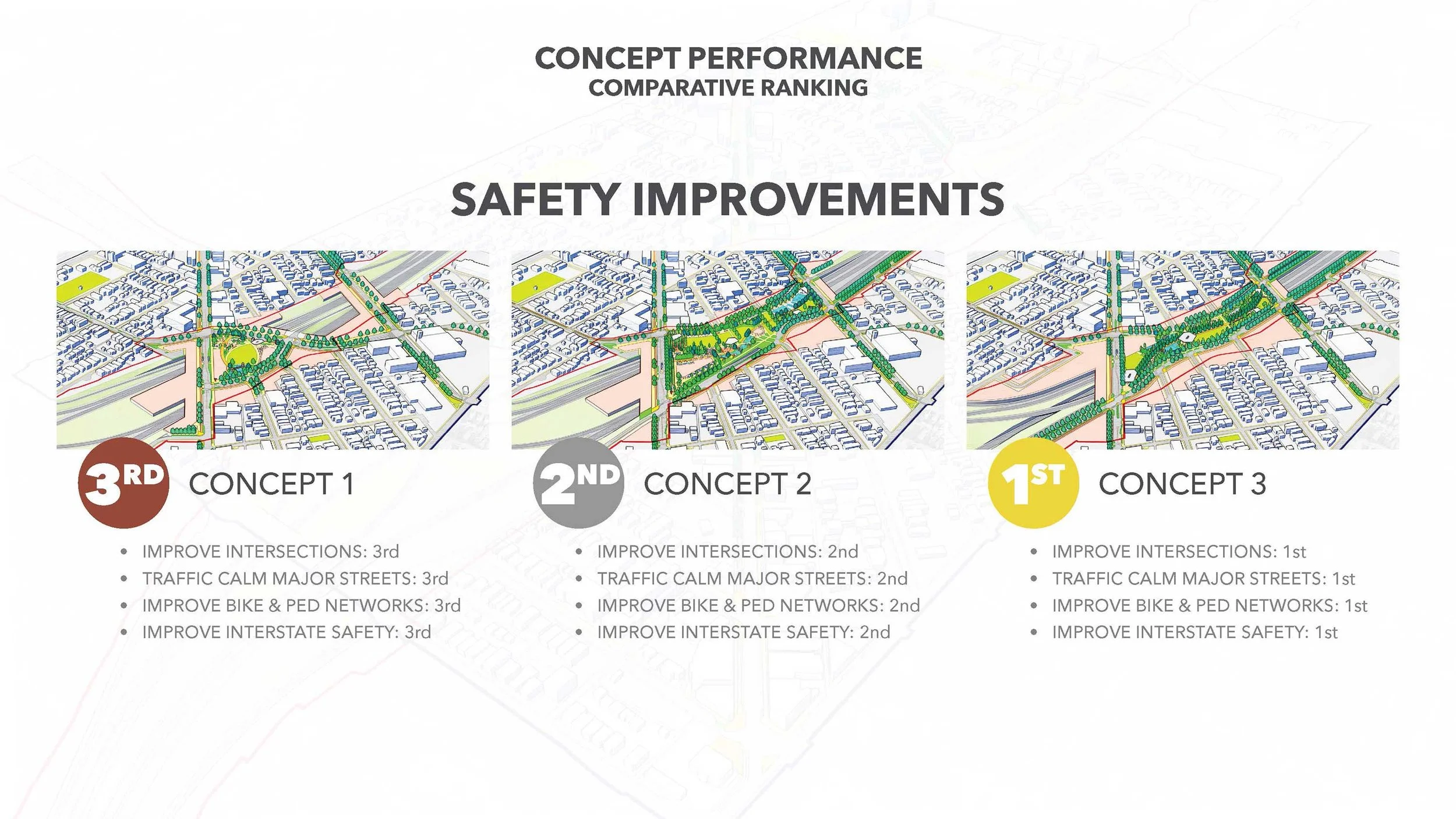
Cap Concepts
The TDE Team developed three cap design concepts and ranked them on key factors and project goals. Their Conditions Assessment Report provides details about the three concepts. (Attachment 12) The discussion below provides an overview of the concepts, their rankings, and associated costs and benefits as presented during Workshop #3. (Attachment 13) As explained in Workshop #3, the three concepts are not final plans. Advancing any of the concepts to design and construction will require robust stakeholder and community collaboration to arrive at an optimal final design.
Also, the Study results must account for design considerations beyond the Study Area. Diving into those considerations was outside the scope of this Study. See the final section of this Report, Next Steps to a Better Future, for more discussion of these implications.
Concept 3 (Preferred)
Concept 3 is the most complex and most transformational. It involves modifying the current interstate configuration and will require INDOT and the City to deal with traffic challenges and potential lane reconfigurations outside the Study Area. The Washington Street interchange is one example. As reflected in the next section, Analysis of Key Objectives for Each Concept, Concept 3 offers the greatest return on investment, including achieving the economic returns necessary to fund the Plan.
Images showing Concept 3 and its integration with the interstate right-of-way (red line) and newly developable land (highlighted in peach) previously in the interstate right-of-way.
Concept 2 (Medium complexity)
This option can be built over the existing interstate and would not require modifications to the interstate outside the Study Area. We will still be asking the State to relinquish land for development, but the ask is much smaller.
Images showing Concept 2 and its integration with the interstate right-of-way (red line) and newly developable land (highlighted in peach) previously in the interstate right-of-way.
Concept 1 (Least complex)
This option can be built over the existing interstate and would not require modifications to the interstate outside the Study Area. We will still be asking the State to relinquish land for development, but the ask is much smaller.
Images showing Concept 1 and its integration with the interstate right-of-way (red line) and newly developable land (highlighted in peach) previously in the interstate right-of-way.
Analysis of Key Objectives for Each Concept
#1: Improve Quality of Life
Priorities:
Build a lot more housing, including affordable and mixed-use options; add more jobs; and increase access to amenities, services, and third places where people can gather, socialize, and build community.
#2: Increase Connectivity
Priorities:
Improve walkability, expand the biking network, increase transit usage through transit-oriented development, and improve driving infrastructure.
#3: Make the Streets Safer
Priorities:
Improve dangerous intersections, calm traffic on major thoroughfares, and make pedestrian and cycling networks safer. The interstates in the Study Area and those just beyond experienced 17 serious crashes over 6 years, 2 of which were fatal. The local street network recorded 80 crashes, 2 of which were serious and 1 involved a pedestrian.
#4: Reduce the Environmental Impact of the Interstates
Priorities:
Reduce noise and air pollution, reduce the interstates’ visual impacts, and repurpose interstate land for more productive uses.
Priorities:
Maximize the quality and value of land and increase the local tax base.
#5: Create Opportunities for Economic Development
Investment Returns
No infrastructure project of great magnitude makes sense unless we can expect substantial returns on the investment. Fortunately, the SE Gateway Plan provides that return with Concept 3, providing the greatest returns. More importantly, in conjunction with the System-Wide Vision, the SE Gateway Plan will help turn billions of dollars INDOT is already projecting to spend in downtown Indianapolis, as outlined in ProPEL Indy, into an investment with exponential returns in economic growth, increased safety, and improved quality of life.
Focusing just on the SE Gateway Plan, the economic potential underscores both the scale of losses caused by the original interstate construction and the transformative redevelopment opportunities created by the three proposed concepts. As detailed in the Conditions Assessment Report (Attachment 12), in 1956, before the interstate was built, the affected corridor supported a vibrant economic landscape. The following table shows the assets located within what would become the interstate right-of-way, their value, and what is located within the right-of-way today:
Right-of-Way Land Use and Value
1956
Private property:
59.8 acres
Housing units:
645
Churches:
3
Community centers:
1
Commercial space:
144,000 sq ft
Industrial space:
46,000 sq ft
Total value in today’s dollars:
$241 million
Today
Interstate land:
61 acres
Parkland:
2.2 acres
INDOT owns all the land, generating no taxable value and offering limited local economic benefit.
The three concepts seek to reclaim portions of this right-of-way and convert it back into productive, community-serving land. Each alternative creates a significant redevelopment footprint, although the scale and mix vary, with Concept 3 providing the most substantial redevelopment opportunity:
| Concept 1 | Concept 2 | Concept 3 | |
|---|---|---|---|
|
Reclaimed land for development |
8.2 acres | 7.3 acres | 12.2 acres |
|
Reclaimed land value |
$13.3 million |
$12.0 million |
$20.0 million |
|
Development focus |
Mixed-use |
Blend of mixed-use, commercial, and residential |
Balanced distribution of mixed-use, commercial, and residential |
|
New parkland |
2.4 acres |
6.4 acres |
5.0 acres |
The concepts differ meaningfully in their redevelopment yield—the amount of housing, commercial space, and jobs they support. Concept 3 is the clear leader.
| Concept 1 | Concept 2 | Concept 3 | |
|---|---|---|---|
| Housing |
293–585 units |
301–525 units |
519–891 units |
| Commercial space |
109,000-124,000 sq ft |
90,000-117,000 sq ft |
127,000-146,000 sq ft |
| Jobs |
249-280 |
213-264 |
287-330 |
Notably, Concept 3 could restore more than the equivalent of the 645 homes demolished for interstate construction, representing a powerful step toward neighborhood revitalization.
In addition to direct development impacts, the study evaluated broader economic uplift: land value appreciation, construction investment, and job creation associated with building the new developments. In every category – value appreciation, total redevelopment investment, and construction employment – Concept 3 ranked highest, followed by Concept 1 and then Concept 2. This reflects the larger development footprint enabled by a greater share of reclaimed land in Concept 3.
Taken together, the findings demonstrate that reclaiming interstate right-of-way creates extraordinary opportunities for local economic renewal. While all three concepts deliver measurable benefits, Concept 3 yields the strongest and most far-reaching economic outcomes, with Concept 1 providing moderate gains and Concept 2 offering modest but meaningful improvements. The analysis makes clear that strategic urban design interventions can reverse decades of economic disinvestment by restoring land to productive use, generating a new tax base, supporting job creation, and rebuilding the economic foundation of the Southeast Gateway community. With intentional integration across planning, design, and implementation, the Plan ensures that infrastructure investments reflect community identity while advancing long-term economic and social vitality.
Funding and Governance for Long-Term Success
Funding
While the benefits of the SE Gateway Plan, alone and in conjunction with the System-Wide Vision, are compelling, an obvious question is, can Indiana afford to do this? More importantly, can Indiana afford not to do this? Over the next 20 years, the State will pour billions into repairing and rebuilding the SE Gateway and Inner Loop interstates. If those billions are spent repairing and rebuilding the interstates “as is,” there’s no opportunity for meaningful economic return.
Instead, we’ll extend outdated 1960s-style interstate design well into the 21st century, leaving Indianapolis with a broken, disjointed transportation system that divides neighborhoods and causes Indianapolis to fall behind competitor cities around the country. We know from developing the Cultural Trail, removing Market Square Arena, rejuvenating the Downtown Canal, and developing the Monon Trail that transformational infrastructure projects generate exponential positives for Central Indiana’s future, and the positive ripple effects extend well beyond the immediate areas of the projects.
From increasing property values and adding millions in additional property taxes to new housing stock and improved health, these types of projects are worth the investment. (See the Learning from Transformational Projects in Indianapolis section above for a discussion of the returns from each of these projects.) We must find ways to make the billions we’ll spend work for us by leveraging them into a transformational redesign of the interstates.
Funding for the transformational redesign of the SE Gateway as part of the System-Wide Vision would likely draw on several funding sources. The Double Track and West Lake Corridor rail projects in northwest Indiana, which required several hundred million dollars of public investment, provide instructive precedent for how a combination of federal, state, and local government funding sources can be utilized to make a large-scale, transformative project a reality. Similarly, we propose seeking additional federal transportation dollars and earmarks with contributions from local government to close as much of the gap between repairing and rebuilding the SE Gateway and other areas of the Inner Loop “as is” versus rebuilding them in a transformational way. Tolling may provide another source of revenue as the State explores expanding its tolling operations. Private dollars may also be accessed through public-private-partnerships (3Ps) or contributions from stakeholders. Any remaining gap can be filled by a combination of State bonding and appropriations, with substantial expected returns as achieved by major infrastructure projects in other states. For information about other projects, see the Funding and Financing Mechanisms: Compilation of Information Report (Attachment 15) and Survey of US Recessed/Capped Interstate Projects (Attachment 9).
Value Capture
Value capture can provide one element of this economic return. As explained in the attached Value Capture Districts in Indiana Memo, value capture reduces the obstacles to redevelopment or economic development that are not likely to be overcome by the ordinary operations of private enterprise. (Attachment 16) The solution is to use new taxes generated by a redevelopment project to pay for the cost of removing the obstacles. In the case of the SE Gateway and with the System-Wide Vision, this means closing the financial gap between the amount needed to rebuild the Inner Loop with strategic capping, unleashing exponential investment returns, versus rebuilding the interstates with their current elevated design. There are a variety of tools in the value capture toolbox, ranging from traditional property tax value capture (a/k/a tax increment financing or TIF) to special value capture districts.
As explained in the next section, the Study Team recommends using Indiana’s existing Innovation Development District as the value-capture framework that, together with other funding sources, can remove the financial barrier to the System-Wide Vision.
An Innovation Corridor
Given the need to bring together several funding sources, in addition to value capture, the Study Team examined funding and governance structures that would consolidate these sources into a single ecosystem to serve broader economic and community development goals. Incorporating the benefits of the System-Wide Vision, the Study Team recommends the development of an innovation development district or corridor that connects the SE Gateway Planning Area, near Eli Lilly’s corporate headquarters, to tremendous land development opportunities and a rich concentration of existing assets running from I-65 to the north, down West Street to I-70 to the south, continuing east along the south leg of the Inner Loop, incorporating White River to the west, and the Canal to the east. As reflected in these aerial images, this innovation district would connect the Purdue and IU growing downtown university campuses, world-class hospitals, private-sector headquarters and R&D facilities, the 16Tech Innovation District, the Convention Center, sports stadiums, the White River State Park, the Canal, museums, and existing parcels of state-owned land into a seamless, cohesive ecosystem that accelerates economic opportunity, talent flow, shared growth, and quality of place. The interstates and West Street would form the spine that connects these anchors, fueling their growth and offering a dense, connected clustering of firms, researchers, and entrepreneurs, within an integrated urban innovation ecosystem that increases knowledge spillovers and speeds up commercialization.
Aerial map looking south showing key assets along the West Street/Interstate spine.
Why an innovation corridor?
Successful innovation districts are much more than a branding and value capture exercise. They are deliberate urban regeneration and economic transformation tools where land use, governance, and institutional partnerships are part of the innovation system. The success of innovation districts increases when universities, medical centers, and other corporate research institutions are part of the equation. These institutions concentrate talent pipelines, research capacity, and translational infrastructure (labs, incubators, clinical research, etc.), creating durable economic engines in a knowledge economy. There’s a growing body of empirical evidence from the real estate and economic development worlds showing that mature, university-anchored innovation districts often exhibit lower vacancy and rent premiums relative to broader benchmarks—interpreted as evidence of concentrated demand for that ecosystem. (See Article, University-Anchored Innovation Districts (Attachment 17).) Ensuring that everyone has the freedom and opportunity to participate in the ecosystem requires building in governance, workforce pathways, and neighborhood benefit systems. When designed well, innovation districts support resilience and sustainability agendas, by leveraging place-based innovation capacity to tackle climate, health, mobility, and equity goals (not just job counts). (See Article, Mission-Oriented Innovation Districts (Attachment 17).)
Cities pursuing innovation districts are increasingly doing so to:
Diversify post-industrial economies
Anchor downtown revitalization
Attract long-term institutional capital
Build resilience around healthcare + research (in the case of health innovation districts)
Create visible public value from innovation investment
Essentially, innovation districts become a form of civic infrastructure, not just an economic cluster, that incorporate:
Mixed-income housing within or adjacent to districts (not miles away).
Transit-oriented design connecting neighborhoods to jobs and care.
Walkable urban blocks instead of fortress campuses.
Shared civic space: plazas, ground-floor uses, community-serving amenities.
Land value capture: reinvesting rising land values into workforce housing, transit, and infrastructure.
Integration of history, art, and culture to strengthen community identity and support long-term economic and social vitality.
With these features combined, innovation districts create thriving neighborhoods with a diverse mix of land uses and amenities connected by a network of pedestrian and bicycle- friendly streets. (See Article and Report, The Rise of Innovation Districts Article and Report (Attachment 17).)
South Bend, Indiana, is putting these benefits into practice through the development of the Tech and Talent District, envisioned in the Downtown South Bend 2045 Plan. (See Article, South Bend RDC Approves $31M Bond to Advance Notre Dame Tech and Talent District (Attachment 17).) With the University of Notre Dame serving as the anchor institution and strategic driver, South Bend is demonstrating the value of partnering with universities and other institutional stakeholders to catalyze economic development, innovation, and civic infrastructure investment.
What kind of innovation corridor?
With the array of university, human life, and animal sciences institutional and corporate assets already present in the proposed corridor, the Study Team recommends positioning the corridor as the country’s leading integrated human-animal health innovation corridor linking discovery, care, education, manufacturing, and community development along the reconnected urban spine. Essentially, we’d be creating an urban circulatory system that physically connects institutions that already collaborate to some extent, turns the interstates and arterial streets into innovation infrastructure, and aligns land-use, mobility, environment, business, and community-growth goals. Many cities can claim biotech, OR medical education, OR animal health, OR medicine research and manufacturing. Indiana can claim all four along a single urban spine in downtown Indianapolis. That’s not branding. That’s structure.
Governance
To set the innovation corridor up for success, we must pay careful attention to how the corridor is integrated and functions. The current literature and studies of life science innovation districts caution that promised benefits, such as job pipelines and knowledge spillovers, don’t occur automatically. Workforce development and social infrastructure, like convening, translational support, talent circulation, and partner coordination, must be embedded from the beginning.
Across the literature, strong districts share six traits:
Clinical + research integration (not just office/lab space)
Anchor-led governance (universities/hospitals at the table, not just developers)
Translational infrastructure (incubators, shared labs, IRB coordination)
Workforce circulation and ladders tied to local institutions (works well beyond talent attraction)
Mixed-use urban form (integrated housing, employment, retail, civic, cultural, an recreational functions)
Explicit public benefit framing (health outcomes, resilience, cultural identity, quality of life considerations)
Achieving these six traits requires a governance structure with representation from a broad spectrum of stakeholders, including State and City government, universities and hospitals, nonprofit entities, private businesses, developers, and community partners.
We recommend creating a nonprofit corporation with a board of directors comprised of representatives from these sectors and a mission dedicated solely to developing and ensuring the success of the innovation corridor. This corporation would solicit and secure funding from a variety of sources and partner with the Indiana Economic Development Corporation to maximize value capture from within the innovation corridor.
The 16 Tech Innovation District on the near northwest side of Indianapolis provides an excellent example of this type of governance arrangement. This district utilizes tradition property tax increment finance (TIF) and the certified technology park statute for value capture, controlled by the local Metropolitan Development Commission, but in a broader sense is governed and operated by the 16 Tech Community Corporation, a nonprofit organization whose board of directors has representatives from the nonprofit, private business, university, healthcare, state government, and local government sectors. 16 Tech Community Corporation also has a full-time staff headed up by its President/CEO, who also serves on the board.
We believe that the creation of a similar nonprofit entity to govern and operate the proposed innovation corridor will help ensure that the vision, energy, and focus needed for its ultimate success are achievable.
Launching the Next Era of Growth
Innovation Corridor Development: Roadmap
The following phased roadmap outlines a clear, actionable path to launch and advance the downtown Indianapolis innovation corridor.
Ongoing Engagement
Continue engagement with key stakeholders, State decisionmakers, City and community leaders, and residents to support the formation of the Corridor as an innovation district under Indiana’s statutory framework.
Initial Assessment
Complete an Initial Assessment, already underway, of the economic potential, building on the findings of this SE Gateway Planning Study, ProPEL Indy, and the 2021 Inner Loop Comparative Study, supplemented by targeted data collection and analysis, including:
Collecting and analyzing existing strategic, facility, infrastructure and campus master plans from relevant stakeholders/partners to develop a baseline feasibility assessment of the Corridor
Developing illustrations of potential redevelopment along the Corridor
Innovation Corridor Planning
Complete a multi-phased Innovation Corridor Planning effort on par with this SE Gateway Planning Study that involves key stakeholders, City leaders and agencies, residents and community leaders, INDOT, and State decisionmakers.
Key objectives of the study would include:
Strengthen workforce pathways to attract, develop, and retain top-tier talent in the Hoosier state.
Encourage a spectrum of innovation to increase demand for cutting-edge technology and labs.
Support existing life sciences enterprises and grow the sector to greater global competitiveness.
Ensure the physical infrastructure supports district connectivity, quality of place, talent attraction, expected growth, and community development priorities.
Guide quality of life investments to support the Corridor’s vision and Indianapolis’ competitiveness.
Provide a flexible and cohesive development and action plan that accommodates expected growth scenarios.
Phase I
Phase I of the Innovation Corridor Planning Study would refine the Initial Assessment and develop preliminary design strategies and alternatives along West Street as it intersects with I-65 to the north and I-70 to the south. Phase I would include:
Land use and parcel analysis
Transportation analysis
Real estate market analysis
Strengths, weaknesses, opportunities, and challenges analysis focused on aligning and creating synergies between institutions and stakeholders
High-level design strategies and alternatives development
Innovation Development District Feasibility Analysis that includes modeling the economic and fiscal implications of the full area redevelopment strategy, estimating the IDD-related revenue streams, and integrating economic findings into the redevelopment strategy.
Stakeholder and community engagement
Phase II
Phase II of the Innovation Corridor Planning Study would further develop the results of Phase I leading to a Master Plan for the Innovation Corridor that includes:
Transportation and development plans
Detailed economic impact analysis
Funding and implementation strategy
Stakeholder and community engagement
Implement the Master Plan
This timing is ambitious but necessary to ensure the innovation corridor’s development aligns with INDOT’s plans to reconstruct segments of the Inner Loop according to the ProPEL Indy schedule.
Supporting Reports and Resources
Southeast Gateway Planning Study Historical Research Narrative and Findings
Indianapolis Downtown Interstate 65/70 System Strategic Advisory (Arup, 2018)
Indianapolis Inner Loop Total Value Report and Executive Summary (Arup and Indy Chamber, 2021)
Rethink Coalition ProPEL Indy 2025 10-5 Comment Letter with Attachments
Reasons to Love the Indianapolis Cultural Trail - A Legacy of Gene and Marilyn Glick (Indiana University Public Policy Institute, 2015)
Assessment of the Impact of the Indianapolis Cultural Trail: A Legacy of Gene and Marilyn Glick (Indiana University Public Policy Institute, 2015)
Indianapolis Transformational Project Overview (Ginovus, 2023)
Southeast Gateway Planning Study Survey of US Recessed/Capped Interstate Projects
Southeast Gateway Planning Study Community Engagement Report
Southeast Gateway Planning Study Conditions Assessment
Appendix A. Location Maps Final Report
Appendix B. Traffic Analysis Memo
Appendix C. Environmental Constraints Report
Appendix E. Schematic Drawings
Appendix F. Opinion of Probable Cost
Appendix G. Final Concept Alternatives Definition Memorandum
Southeast Gateway Planning Study Community Engagement Workshop #3 Presentation Slides
Southeast Gateway Planning Study Funding and Financing Mechanisms: Compilation of
Southeast Gateway Planning Study Value Capture Districts in Indiana Memo
Articles:
University-Anchored Innovation Districts
Mission-Oriented Innovation Districts
The Rise of Innovation Districts (Article and Report)
South Bend RDC Approves $31M Bond to Advance Notre Dame Tech and Talent District
Southeast Gateway Planning Study Abandoned Railroad Bridge Memo